![]()


Territorial Waters, Continental Shelf and EEZ. The Greco-Turkish case
27.02.20
Territorial Waters, Continental Shelf and EEZ. The Greco-Turkish case
Analysis of the special working group of the New Left Current (NAR) for the Communist Liberation
The broader context and the attitude of the communist left
Introductory remarks
The issues of the delimitation of the maritime zones between Greece and Turkey and other neighboring states, namely the Territorial Waters, the Continental Shelf and the EEZ (Exclusive Economic Zones) are coming up with rising tension.
The targets of the smoke screenings about the “small and defensive" Greece, or the "strangling of Turkey" respectively, are obviously different from those presented in the national rhetoric of both states. They are related, inter alia, with the aims and aspirations of the Greek, Turkish and international capital, and their heart is the sharing of the exploitation of the hydrocarbon deposits in the Eastern Mediterranean.
It is important to emphasize that the disputes over the maritime routes and the exploitation of seas in general are escalating around the world. Typical examples are Russia's conflicts with other countries over the control of the Northern Sea Route (Europe-Asia connection via the North Pole in conjunction with the ice-melting process) and those of China with the US and other countries over the South China Sea.
A number of problems and controversies have arisen over the delimitation of maritime zones, one of which is the Greek-Turkish dispute. The differences reflect not only the existence of ambiguities and contradictions in the provisions of the so-called International Law, but mainly the political and economic aspirations of the bourgeoisie of the two countries, as well as the hegemonic capitalist states and imperialist coalitions.
The key starting points for the view through which this issue is approached by NAR for the Communist Liberation are:
- To defend the interests of the peoples of Greece, Turkey and the Mediterranean in general, under the perspective of internationalist cooperation. The peoples can jointly decide whether and what resources to exploit, the feasibility and the terms of the potential exploitation.
- The fight against the rise of military spending and the general war readiness and preparation, the prevention of military adventurism and of a possible war in the region, the fight against the adventuristic plans of the big and small (regional and local) imperialisms and the separate bourgeois classes.
- To protect the environment through the resistance to the creation of sea-blocks of the seas and their surrender to the Multinational Mining Monopolies.
- To prevent the nightmare prospect of yet another century of oil and fossil fuel economy when the negative effects of climate change are already being experienced.
This text is the fruit of a collective work by a working group of the New Left Current (NAR) for the Communist Liberation and it does not cover all aspects related to the competition between the bourgeoisie of Greece and Turkey, but within this framework, it seeks to identify those aspects that arise from differences in the issue of maritime zones.
It also does not cover the wider context of Greek-Turkish relations, which include cooperation as well and an alliance between the bourgeoisie in the two countries: they both participate in NATO, Greece supports Turkey's accession to the EU, both countries cooperate for the implementation of the EU-Turkey Joint Declaration on Refugees, etc.
Our ambition is to contribute to the broader debate within the communist left, at a time when not only nationalist cries and rivalries in the region are escalating, but many states are directly or indirectly involved, including Greece and Turkey, or support warfare or wage a social war against peoples, always speaking hypocritically in terms of "national rights" and "national unity".
On the Law of the Sea in general
With regard to the "Law of the Sea", aspects of which will be further developed below, it is emphasized that - especially in its current evolution - it is increasingly being transformed into an "unjust" law, cut and stitched within the interests of the leading capitalist states. Through the domains they have maintained since the era of the empires, they have already appropriated huge maritime lands often depriving them of coastal states. A most striking example is that of the ABC islands off the coast of Venezuela, under which Holland claims - and exercises sovereignty – in a large part of the Caribbean. The increasing ambiguity of the Treaties and the urge for a "fair" deal are all the more turning a blind eye to the so-called "political solution", that is to say, the law of the powerful ones.
At the same time, the text stresses the discretionary interpretation of the relevant provisions of the International Treaties on the part of the Greek governments (and those of Turkey respectively) so as to defend their positions according to the interests of the bourgeoisie.
On the maritime zones in general
Till the end of World War II, the basic concept of the sea was primarily concerned with navigation, commerce and / or war. So basically the sea was a “road”. Secondly, the sea was also a productive area through fishing and marginally (in the ports) through the shipbuilding industry. But that was it.
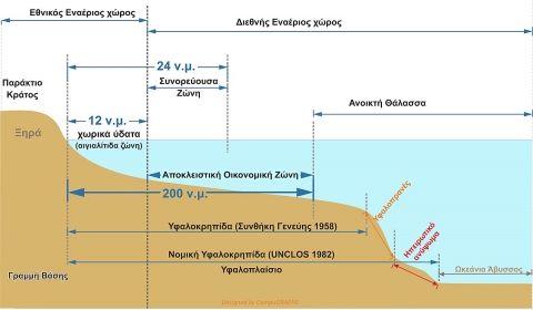
Developed capitalist states, beginning with the US and France, began to speak gradually about the Territorial Waters, that is, a maritime zone around the states' coasts, with some latitude. The state's full sovereignty over land thus extended to a part of the adjacent sea. The justification for this was essentially political and concerned the capability of defense.
Initially, the width of this zone was set by different states at 3 nautical miles, as far as a cannon could fire at those times. The exercise of state sovereignty over the territorial waters, however, has some peculiarities, as it is not prohibited for the ships of other countries to pass from there, in so far as it is an “innocent passage”, that is to say, “as long as it does not interfere with peace, the smooth operation or the security of the coastal state."
In short, the ship transit is under control1 and anything other than simple passage (e.g. fishing, transshipment, military drills, etc.) is expressly prohibited. As for submarines, they must sail on the surface. Beyond the Territorial Water Zone, a contiguous zone is defined, where the coastal state does not exercise sovereignty, but has rights of control in order to prevent crime.
The vast majority of coastal countries gradually set their territorial waters at 3 nautical miles. This was originally done by Greece and Turkey too.
The confrontation between Greece and Turkey over the width of the Territorial Waters did not always have the same significance and intensity. Between these two countries, it is Greece that unilaterally diversified the width of the territorial waters with two significant moves (even before any international treaty was drafted).
In 1931 it expanded2 the width of the airspace from 3 to 10 nautical miles. According to customary international law and subsequent treaties, the width of the airspace must coincide with the width of the territorial waters. This means that that "paradox" and unique in the international practice choice of Greece raised the question of expanding its Territorial Waters.
Indeed, in 19363 Greece announced - again unilaterally - that it would extend its Territorial Waters to 6 nautical miles. So did the Greek paradox of different widths in maritime and airspace sovereignty remain till the present. It should be noted that this is usually where the military confrontations between Greece and Turkey take place almost daily, with the latter denying that these are violations, as it considers this 4-mile difference between Greece's maritime and air sovereignty illegal.
Turkey responded in 19644 by extending its territorial waters also to 6 miles. As far as the Black Sea is concerned, after negotiations with the USSR, Bulgaria, etc., Turkey’s Territorial Waters were expanded to 12 miles.
Immediately after the end of World War II, US President Harry Truman, for the first time, announced the jurisdiction over research and economic exploitation in the seabed and subsoil of a maritime zone wider and beyond the Territorial Waters up to the point where the sea depth reaches up to 200 meters. This zone was named Continental Shelf and practically this first description, with its inherent vagueness, had a strong correlation with the geological definition of the Continental Shelf as an extension of the land in the (shallow) sea and was associated with the technological possibility of its exploitation (down to 200 meters of sea depth), while there was no other mention of the breadth of this zone.
The growing importance of this shift was materialized in the International Convention for the Continental Shelf of 1958. According to the definition that was given by this Convention, the Continental Shelf of a state expands until the part of the sea depth located around its shores and beyond the territorial waters down to 200 meters, unless it is possible to exploit the natural resources in deeper waters, therefore it expands until that breadth.
In short, using that last window, the new definition expanded the limits (breadth) of the Continental Shelf, by greatly disassociating the legal definition from the geological term of the Continental Shelf (the continuation of land in the sea). It didn't even set any limit for this breadth. Essentially the only criterion set was that of the “possibility of exploitation”.
Practically, the driving force of this expansion was the exploration and exploitation of the natural resources in the seabed and the underground of the Continental Shelf's maritime zone.
This definition was drastically altered - again in the direction of the expansion- through the United Nations Convention on the Law of the Sea5 (Montego Bay Convention), which was signed in 1982, following a series of failed interstate negotiations.6
According to the new definition given by article 76 of the Convention:
“The Continental Shelf of a coastal state is comprised of the seabed and its underground that expands beyond its territorial waters throughout the range of the natural extension of its land until the outer limit of the Continental Margin or until a distance of 200 nautical miles from the baselines from which the breadth of the Territorial Waters is measured, where the outer limit of the Continental Margin does not expand to this distance”.
Thus for the fist time the breadth of 200 nautical miles is set, independently from the “natural extension of the land”, while simultaneously the reference “throughout the range of the natural extension” offers the possibility of an extension beyond the 200 nautical miles. Indeed, in another article the possibility of extending up until 350 nautical miles is offered.
The same 1982 convention, in Article 3, regarding the Territorial Waters defines that:“Every State has the right to establish the breadth of its Territorial Waters up to a limit not exceeding 12 nautical miles, measured from baselines determined in accordance with this Convention.”
In Article 121 this Convention expands further on its regulations for Territorial Waters (as well as the Continental Shelf and the EEZ) in the islands too, by stating that:
“The Territorial Waters, the contiguous zone, the exclusive economic zone and the continental shelf of an island are determined in accordance with the provisions of this Convention applicable to other land territory.”
Also important are the references and regulations of that same Convention in the matter of the Exclusive Economic Zones (EEZ), the significance of which is constantly increasing.
Article 55 referring to the “specific legal regime” of the exclusive economic zone defines the latter as the zone lying “beyond and adjacent to the Maritime Zone” and -according to article 57- “shall not extend beyond 200 nautical miles from the baselines from which the breadth of the Territorial Waters is measured”
In this case, the dissociation from any form of geological definition is complete. The EEZ is a legal, political term, defined with the criterion of the breath of the zone (200 nautical miles).
Seemingly, it coincides with the Continental Shelf, but this is not the case, for various legal and practical reasons.
The primary reason is clarified in Article 56, where it is expressed that in the exclusive economic zone the coastal state has rights that aim to explore, exploit, retain and manage its natural resources - living or not -, the waters over its seafloor, its seafloor and the underground below it, as well as other activities for the financial exploitation and exploration of the zone, such as the production of hydro-power or wind-power.
Therefore, even though the meaning of the Continental Shelf maintains its autonomy and its importance regarding the exploitation of the seafloor and the underground below it, in the EEZ zone the state has exclusive rights of exploitation in the water columns as well, regarding fishing, energy, etc.
This time this “expansion” is deployed in the vertical sense and this is extremely important.
Greece and Turkey have not come to an agreement on the delimitation of the Continental Shelf or the EEZ.
Interpretations and problems with the delimitation of the sea zones
The Convention on the Law of the Sea, with the definitions it provided, did not solve the issue of the different interpretations. On the contrary, it gave rise to new questions.
We should make clear from the start that nowhere does this Convention, as well as the previous one for the Continental Shelf of 1958, define that a state must or can unimpededly expand its territorial waters or its Continental Shelf up to 12 and 200 nautical miles respectively. On the contrary, it defines that it can, it has the right to expand them until these limits, provided of course that this expansion does not collide with other states with equivalent rights. Truthfully, there are very few coastal countries all over the world that can unimpededly expand, throughout their territory, all three sea zones until their upper limits.
Both conventions include certain provisions regarding this issue.
Article 83 of the Convention on the Law of the Sea, defines the following, regarding the delimitation of the Continental Shelf between states with opposite or adjacent coasts:
“The delimitation of the continental shelf between States with opposite or adjacent coasts shall be effected by agreement on the basis of international law, as referred to in Article 38 of the Statute of the International Court of Justice, in order to achieve an equitable solution”
The same provision appears in Article 74 regarding the delimitation of the Exclusive Economic Zone between states with opposite or adjacent shores
In any case, neither the EEZ nor the Continental Shelf can be announced unilaterally by a country.
At this point we should notice that the provision for the Continental Shelf is significantly amended compared to what was defined in the previous Convetion on the Continental Shelf of 19587, where, in Article 6, it was mentioned that:
“Where the same continental shelf is adjacent to the territories of two or more States whose coasts are opposite each other, the boundary of the continental shelf appertaining to such States shall be determined by agreement between them. In the absence of agreement, and unless another boundary line is justified by special circumstances, the boundary is the median line”.
In the new definitions the explicit reference in the start of the median line is removed and there is even more emphasis on the agreement through negotiations.
In the case of the delimitation of the Territorial Waters between states with opposite or adjacent coasts, in Article 15 of the Convention on the Law of the Sea, the start of the median line is mentioned, with the note that: “the above provision does not apply, however, where it is necessary by reason of historic title or other special circumstances to delimit the Territorial Waters of the two States in a way which is at variance therewith”.
The Convention does not clarify what could these “special circumstances” be, even though article 123 refers specifically to states bordering with enclosed or semi-enclosed seas, stating that: “they should cooperate with each other in the exercise of their rights and on the performance of their duties under this Convention”.
The same issue applies to the case of islands existing between states that have coasts opposite to one another. The convention declares that islands too have sea zones, though without determining how these zones are specifically determined, in order for the principle of equity to be respected. The existing legislation through appeals in Courts, includes cases of full effect of the provision for Continental Shelf (and EEZ) to the islands, partial and/or no effect, in combination with the position, the size of the islands, the width of the coasts and other factors.
Even more vague is the reference to the need for negotiations between states in order to reach an agreement regarding the exercise of their rights. The rationale of the convention is set in Article 300 where it is pointed out that:
“States Parties shall fulfill in good faith the obligations assumed under this Convention and shall exercise the rights, jurisdiction and freedoms recognized in this Convention in a manner which would not constitute an abuse of right”
The Greco-Turkish dispute
It is logical that in a region with as a unique geographical configuration as the Aegean, and with the political and strategic importance of the wider region, one would not expect a seamless exercise of maritime rights by Greece and Turkey.
A careful examination of the claims made by the respective governments of Greece and Turkey shows that the bourgeoisie of both countries, with their own separate interests in mind (and depending on their alliances), view the International Conventions as they see fit. In this way they risk war, fueling hostility and maintaining an arms race that the peoples on both sides of the Aegean cannot bear.
Regarding the Territorial Waters (coastal zone) Greece8 talks about the "right to extend to 12 miles", considering that there is no special circumstance in the geographical configuration in the Aegean and thus no need for negotiation with Turkey. However, things are very different: If the width of the Territorial Waters remains at 6 miles (as it has been for almost 80 years since 1936), Greece's Territorial Waters will constitute 43.5% of the Aegean Sea, Turkey’s 7.5% and International Waters 49%. In the case of the extension of the Territorial Waters to 12 miles, then the Greek territorial waters will constitute 71.5% of the Aegean, with the Turkish Territorial Waters at 8.8% and the International Waters at 19.7%.9
That is to say, the Aegean will be transformed into a Greek lake, with Turkey becoming extremely restricted, while international shipping will be forced to navigate on routes that not even Greek shipping would prefer, let alone states such as Russia. Any ship that now crosses the Aegean will have to prove that it is on innocent passage. The unilateral extension of the Greek 12 miles therefore constitutes an adventuristic act, with potentially serious repercussions for the Greek and Turkish peoples, while lacking any notion of justice and realism. It is noted that Turkey has since 1995 declared any such step a cause for war (casus belli). On the contrary, a negotiation and special agreement on the Aegean, with a voluntary partial renunciation by Greece of the "right of extension", could follow the path of logic, through negotiation and agreements on territorial waters in a beneficial way for both countries, but also with corridors for international navigation. Many countries have done the same, especially in the case of sea bays, narrow passages, etc. Japan has agreed to 3 Nautical miles of land for its straits with its neighboring countries. Estonia is also in agreement with Finland and Russia in the Gulf of Finland, as are other countries too.
The stalemate of the "national strategy" that all postwar Greek governments support on this issue and the search for a way out through compromises is also evident in the views of legal scholars such as H. Rozakis (peer professor of International Law in the UoA) who recently suggested another approach:
"Our proposal is to have a 10 nm settlement, which will also be in the interest of the national airspace (which is now harmonized with the breadth of the coast), that is up to now an international anomaly, and in the interest of third countries crossing the Aegean, who, should the coastline be expanded to 12 pm, would be obliged to apply the innocent passage, whatever that entails.10
As far as the Continental Shelf (and the EEZ) is concerned, of the Convention's provisions and the zoning of the islands Greece "remembers" only the 200 miles. It thus argues that the separation with Turkey should be based on the principle of the middle line between the eastern coasts of the Greek islands of the Eastern Aegean and the Turkish coasts, ignoring the Convention’s provision for negotiation and agreement in "special circumstances". It thus nonsensically does not declare an EEZ because the outcome of a court case would be at least dubious (especially regarding Kastelorizo), but carries around maps of the EEZ with engraved Sea Blocks and makes arrangements with multinational mining companies accompanied by war frigates. These maps, in which the Greek approach is applied, naturally give the entire Aegean to the Greek EEZ, while Turkey is even displaced from the Eastern Mediterranean Sea through the recognition of a (full) EEZ for the Greek island of Kastelorizo/Megisti: With the latter move, Greece, acquires maritime borders with Cyprus thus sharing along with Cyprus, Egypt and Israel almost all of the Eastern Mediterranean Sea.
Greece has already suffered a defeat in its only appeal in 1976 to the International Court of Justice in The Hague, which on the one hand rejected the application of provisional measures against Turkey (which carried out "investigations" in areas of the Aegean that Greece considers to be part of its continental shelf) and on the other hand in its 1978 decision11 stated that in the substance of the matter, it cannot take a position in favor of the Greek allegations. The court could not designate any shelf boundary since the two states had never prepared any alternative agreement between them, even if the dispute had been recognized.Dozens of other cases have reached the International Court, refuting Greek positions which deny that islands so close to the opposite state, constitute a "special occasion". In the case of the British-French dispute12 the Court's ruling was that the British Isles near the coast of France should not granted a continental shelf, but only territorial waters and set the boundary at the beginning of the mid-line between the continental coasts.
In the case of Libya-Malta13 dispute over the Shelf and EEZ, the court considered that the 200 nautical mile criterion and the mid-line principle could not be used exclusively, but also by taking into account the principle of 'proportionality', that is to say the length of the coast of the two countries shifted the border at the expense of Malta. Similar decisions have been made in other continental shelf conflicts such as between Canada-US (1984)14 for the Gulf of Maine, Tunisia-Libya (1982)15, Canada-France (1992)16 where the EEZ was limited to a very narrow strip, Norway-Denmark (1993)17, where the mid-line was again modified taking into account other criteria, Bahrain-Qatar (2001)18 et al. The Court’s ruling on the Romania-Ukraine conflict (2009)19 which defined the continental shelf zone ignoring the Serpents Island et al is very important for the Greek-Turkish dispute. Almost all Court cases involved disputes over the presence of islands closer to the opposite state than to the one they belong to.
On the other hand20, from the existing definitions of the Continental shelf and the EEZ, Turkey only “remembers” the definition of the continental shelf as “a natural prolongation of the land in the sea” which has now been repealed. The Turkish government claims, relying on some judgments given for comparable cases that the Greek islands of the Eastern Aegean lie on the natural prolongation of its coasts, thus they do not have a continental shelf. From their point of view, the continental shelf can be defined only by using the principle of the middle line between the mainland coasts of the two countries. Based on that approach, Turkey claims half of the Aegean Sea. But these allegations are unsubstantiated, mainly because the islands of the Eastern Aegean are not either isolated or cut off from the mainland of Greece, as in other cases which had been tried. They are part of the group of the, 3000 and more, islands in the Aegean (about 150 of them are inhabited). Their formation, while not classifying Greece as an archipelago-state, attributes to it the status of an island county. The Turkish political stands take their extreme form when they ignore the total of the Greek islands (Rhodes, Karpathos, Crete), as in this case, they ask for the delimitation of EEZs based on the tenet of the equal distance from the coasts of Libya, Egypt, and Lebanon. In that way Turkey shares the Eastern Mediterranean excluding Greece and Cyprus. In the graph below, there appears the sharing of the EEZ between Turkey and Libya. We can notice the circumvention of the EEZ of Crete, Rhodes, Karpathos, etc (Turkey supports that the EEZ of these islands should be ignored.)21
Also, Turkey, while referring to the special circumstances and the proportionality principle, for example the length of the coasts of Kastelorizo/Megisti in contrast with the opposite Turkish coasts, is not willing to get into a negotiation by taking into consideration the same principle in the Aegean Sea.
The rhetoric about the need for negotiation that Turkey develops over time cannot hide its basic orientation. By supporting that the decisions which were imprinted in the Treaty of Lausanne do not reflect the current strength of Turkish capitalism, neither the correlation of strength with Greece, Turkey is looking for the pretext but also moves to aggressive initiatives in order to put everything on the negotiating table, even issues of sovereignty which concern islets of the Aegean.
However, any appeal to an international court would oblige the Turkish government to recognize the EEZ of Cyprus and at the same time the EEZ of Rhodes, Crete, and Karpathos, something that does not satisfy the even greater aspirations of the Turkish bourgeoisie for the role of a regional superpower that wants to assume in the Eastern Mediterranean.
Where does the antagonism between the Greek and Turkish bourgeoisie lead?
Since neither the path of negotiation nor the appeal to a court is selected, even if possible, what could be the outcome of the conflict? Under the particular strategy of the two countries’ bourgeoisie, two possible developments are being formed.
The first one is historically - but at present too - based on the conviction that they will win the competition against the opposite state through exhibiting an excess keenness in totally lining up with the USA and NATO as allies. Both countries used to have and still have an important position, especially at the time when the USSR and the Balkan ex-”socialist” countries still existed while the time-bomb of the Arab-Israeli conflict posed a significant threat too. Moreover, Greece used to and still bets in its participation in the EU.22 In particular, at present, it strives to take advantage of the EU’s general attempt to reduce its energy dependence from Russia by differentiating gas resources but also its routes of transport. In that context, one can also understand EU’s support for the construction plan of the huge undersea pipeline (EastMed) connecting Egypt, Israel, and Cyprus with Europe, through Greece and Italy. In this direction, the Greek side has recently thought to have a big triumph due to the appearance in official EU-maps of the local ΕΕΖs which coincided with the positions of the Greek side.23
From this competition which attaches them to the imperialist axes, the people of both countries find themselves on the losing side as it is them who pay for the military equipment and are fed with nationalistic poison. The Greek side however hesitates to declare the EEZ before it feels that it has secured the military support of big imperialistic powers like the USA, France and/or Israel. For this reason, it uses Cyprus as the “rabbit”. Turkey follows the same pattern. In the case of the recourse to the international courts, both sides expect a positive result, probably in favor of the side of which will be to a bigger and more convincing extent in harmony with the US (and not only) plans.
This path does not exclude aggressive moves of enforcing one country’s will on the other, with military actions or other provocations. This is the reason behind the Turkish invasion of Cyprus, the Greek threats to extend its sea-waters to 12 miles, but also the mutual game with the fire both in the water and the airspace of the Aegean and its small uninhabited islets for the creation of a “fait accompli”. This path is a catastrophic dead end for both the Turkish and Greek people.
Erdogan’s reactionary regime, since it is going through a multifaceted crisis but is also in a process of reconfiguring its alliances, would really like a risky provocation from the side of Greece (e.g. a unilateral declaration of EEZ or extension of the territorial waters to 12 miles). In the narrow-minded policy of the Greek bourgeoisie, the present disturbance of Turkey's alliance with the USA, appears as a “chance” for unilateral actions, thus seeking for more energetic support from the USA. Of course, at the same time the Greek governments are surrendering everything to the US interests… The formation of the Greece-Israel-Cyprus-Egypt axis and the mining assignments to multi-national corporations without the agreed demarcation of the EEZ by all countries involved, characterized the aggressive and opportunistic political strategy of the SYRIZA-ANEL government and generally of the Greek state. The idea that Greece has to proceed in the unilateral declaration of the EEZ and the delusion that in this process any discussion with Turkey is unnecessary since the alliance with Israel and the USA is enough, seems that has taken the minds of the majority in the Greek establishment.
However, and simultaneously with the escalation of war rhetoric on both sides of the Aegean, a second path cannot be ruled out, namely the possibility of some sort of agreement with the mediation and arbitration of the hegemonic capitalist states. In this case, again interpreting the International Law as they see fit, the delineation of special zones according to the results of exploratory drilling is on the table with the profit-sharing agreements favoring primarily the multinationals and then the capital in Greece and Turkey. Although this development seems very unlikely today, it is not only a key requirement of Turkey, but also an important aspect of the US imperialist strategy, which on the one hand will not accept Turkeyas a forever lost ally, and on the other hand, it aims to ensure "calm waters” and seamless profits for its multinational companies like ExxonMobil.
On the stance of the communist left
It is beyond doubt that the stance of the communist left both in Greece and in Turkey is difficult to be articulated within this context and mainly to become a massive political movement.
In Turkey, it is obvious that within the “emergency state” regime, where terrorizing and imprisoning those who resist is a common practice, anyone who takes a brave, internationalist stance can be accused of as a “traitor” or as a threat to “territorial integrity”, regarding the Kurdish issue.
In Greece, while there is a strong tradition of anti-imperialist and pro-peace action, with a special contribution of the left, at the same time the KKE (Communist Party of Greece)24 and LAE (Popular Unity)25, from different positions and starting points, if not being identical, they surely cannot differentiate from the “national rhetoric” of the Greek bourgeoisie. So, they talk about “the right of the extension of the sea borders to 12 miles”, even accusing the government of “yieldingness”, while many fantasize that the unilateral declaration of the EEZ will bring loads of money that will support the “productive reconstruction” of the country and/or even…socialism.
Our position
In our opinion, the working-class, revolutionary perception develops from that point on when the left stops speaking the language of state policy and in the terms of the so-called “national rights”, but speaks that of peace, that of the right and just and the common good for the two neighboring peoples, as well as that of the environmental protection and socialist ecology.
The communist left in Greece must be in a position to support whatever it says on the matter even if found in a working class neighborhood in Ankara. It must develop a stance that the communists and the left people in Turkey will be proud of and not concealing it. And vice versa of course….
A position that considers the Aegean a Greek Lake and denies the elementary right of living together and cooperation between the two peoples for the utilization of whatever resources considered necessary (in a different context of course) must have no place in the general stance of the Greek communist left.
In our opinion, the issues of the maritime zones must be dealt with on the basis of the principle of justice and through the honest communication between Greece and Turkey and other neighboring peoples. It goes without saying that this cannot be realized by the anti-labor, reactionary, pro-war and NATO governments of the present, in the context of the antagonism between the bourgeois classes of Greece and Turkey. It can be a visible way out, from the moment that in Greece and Turkey the labor, popular movement will impose: the exit from NATO and the EU, breaking free from the aggressive coalitions with the USA, Israel or Russia, the reduction of military spending, the overturn of the anti-labor and murderous for the refugees policies and finally the overthrow of the bourgeois classes in both countries. In other words, it is a matter of struggle of the labor and popular movements in both countries, in an anti-capitalist and anti-imperialist direction.
We are against the unilateral declaration of EEZs or territorial waters at 12 miles because:
a. It is an aggressive action that leads to war paths in a region where the greatest interests worldwide concerning the transport of energy and commodities are in conflict.
b. It serves the interests of the oil giants and not those of the peoples of the region. The exploitation of the hydrocarbons of the potential Greek EEZ by the oil companies will not make Greece look more like Norway (where Statoil is a state-company and all revenues go to a public fund) but more like Nigeria where the notorious crimes of Shell company have taken place. The people of Greece will see no share of the profits made by the Greek oligarchs.
c. The sea area does not wholly and rightfully belong to the Greek state.
d. It is tremendously dangerous for a state such as Greece to “play” with the conflicts among imperialists expecting the International Law to be implemented in its favor (remember the Minor Asia catastrophe).
e. The “leftist” argument that we presently claim EEZs with the backing of the multinational companies so as to have them as a “backup” for socialism is totally hypocritical and submissive to the bourgeois class. With such a left, firstly socialism will never prevail and secondly after the predatory exploitation by the multinational companies, the only thing left for socialism will be the cost of the environmental destruction.
f. If everything “goes well”, the only winners will be the oligarchs, if everything goes wrong the people will pay in blood and yet another refugee crisis.
We say “No!” to another century-long cycle of oil and fossil fuel based economy
The position of the Left should step beyond the idea of a fair arrangement as regards the delimitation of maritime boundaries, as well as entail an overall analysis thereupon, and suggest an entirely different approach. In this respect, several critical issues arise and need to be discussed and addressed.
Should we think about that more deeply, it will be assumed that the fragmentation of sea areas into sea plots for exclusive use, revives in a way the “enclosures”. That practice of expropriation of common agricultural lands by the landowners of 18th century, which was considered by Marx to be the force behind the primitive accumulation, that led to the emergence of capitalism and to the Industrial Revolution. Similar practices of land areas dispossession played a key role in the colonization process and continue today in different forms, which David Harvey describes as practices of “accumulation by dispossession”.
The present process of fragmentation, however, differs in certain aspects. First, in terms of organization: common sea areas are arranged differently from common agricultural lands in the pre-industrial England. Then, currently, the critical factor of division of the producers from the means of production (which was the historical process that formed the modern proletariat, and its double freedom, from both feudal bonds and means of production) is basically absent. Even so, this new form of sea plots enclosures, and the sale and purchase of exclusive exploitation rights creates a market which is necessary for generating income, in a manner proportionate to the obtainment of land rents out of the private, exclusive ownership rights to lands.
Sea enclosures in international waters, and the expansion of relations which generate land-rents income at sea were enabled by the technological development. Technology has made the economic exploitation of the sea and the subsoil possible, and accentuated the tendency of the capital to turn from profit to income, in times of profitability crisis in the sphere of production.
But even within the national territory (Territorial Waters), these same tendencies seem to take effect. Currently, the sea undergoes an even greater economic exploitation; besides all fishing activity, it is also used for recreational purposes mainly by tourism companies (which, in some cases, fence even whole areas to create marine sanctuaries), for aquaculture, for the extraction and the exploitation of hydrocarbons, for the construction of wind farms, etc. Thus, typical land use conflicts, which are regulated by territorial and urban planning, are now affecting the sea as well. It is no coincidence that during the summer of 2018 it was the first time that the framework for the maritime spatial planning was established in Greece, under the relevant European Directive.
It is significant to note that: The surface area of the Earth is approximately 510 million square km, of which about 73% is ocean, and only 27% is land. Namely, the surface area of the Pacific Ocean is larger than the total land area of all continents.
If all coastal countries make use of their rights to establish a 200 nm Exclusive Economic Zone (EEZ), then the entire sea area owned by them will extend approximately to 37.7 million square nm, i.e. 35.8% of the global sea area. Globally, EEZs comprise areas where over 90% of fishing, and over 87% of oil activity is conducted.26 Hence, it is evident that EEZs are critical to both the Law of the Sea, and to the global economy.
Why must it be taken for granted that every position that regards the sea and the land as common heritage which can be neither shared nor divided should be undermined, whereas every attitude in favor of ownership and land renting even at the sea is considered as the “normal” (and/or progressive)?
The fact that marine soil is uninhabited does not downplay the above question nor allow room for contemptuous comments like “some say that seas belong to their fish”. We must be clearly aware of the ongoing environmental disaster: extinct or endangered species, tremendous environmental risks as a result of the capitalist exploitation of the sea… Even phrases that are included in Conventions on the Law of the Sea, such as “exploitation of the living marine resources”, are absolutely repugnant.
The belief in a “fair sharing” of ΕΕΖs is hopelessly delusional, even for small states such as Greece. Practically, the sea is divided into state properties for commercial exploitation, which are intended for sale or rent to large multinational companies and to the major capitalist countries. They are those who are able to take advantage of them. States are killing each other to plant a flag on a territory which is meant to be rented…
There is also another important aspect to underscore in this matter: Due to the technological advancement, which now permits deep-sea oil and gas exploitation, the issue at stake is the introduction of another centuries-long cycle of oil and fossil fuels based economy. From a liberating and communist standpoint, the answer to the energy issue, the ongoing climate change and its repercussions cannot be the above. Quite the contrary; It is essential to capitalize on the technological potential and other factors towards the development of an utterly different energy model which will dismiss the all-pervasive attack and dominion of the totalitarian capitalism of our times to the four corners of the Earth, and generally to the biosphere. Thus, we should push ahead with the overall potential for the communist unification of the humanity, for a peaceful and fair social development in symbiosis with nature.
[i] An example from Cyprus here can be found here: http://www.cylaw.org/nomoi/enop/non-ind/2011_1_28/full.html
[i] Hellenic National Defense National Staff (HNDNS): http://www.geetha.mil.gr/el/violations-gr/121-epexhghseis-orwn.html
[i] US State Department: https://www.state.gov/documents/organization/61548.pdf
[i] Greece cancelled the Convention in 1995 while Turkey has not ratified it so far
[i] The Turkish argument can be read here: http://www.mfa.gov.tr/background-note-on-aegean-disputes.en.mfa
[i] http://www.kathimerini.gr/994610/article/epikairothta/ellada/apoyh-mia-apanthsh-sto-kymati-8alasshs
[i] https://en.wikipedia.org/wiki/Canada%E2%80%93France_Maritime_Boundary_Case#/media/File:Saint-Pierre_and_Miquelon_EEZ_map-en.svg
[i] http://www.kathimerini.gr/995745/gallery/epikairothta/politikh/toyrkikoi-tyxodiwktismoi-epi-xartoy
[i]http://www.kke.gr/anakoinoseis_grafeioy_typoy/dhloseis_toy_gg_ths_ke_toy_kke_dhmhtrh_koytsoympa_apo_thn_episkepsh_toy_sthn_patra?morf=1,


![]()


ΒΙΒΛΙΟΘΗΚΗ


Η ΦΩΤΟΓΡΑΦΙΑ ΤΗΣ ΗΜΕΡΑΣ


![]()


